RV travel and destinations
California Coast Road Trip: Your Complete Guide to Driving the Pacific Coast Highway
Posted on January 25, 2026
Planning a California coast road trip means you're about to drive one of the world's most scenic highways. This guide covers everything from the best route and top stops to where you can park your RV along the Pacific Coast Highway, so you can make the most of your coastal adventure.
Everything You Need to Know About Your California Coastal Road Trip
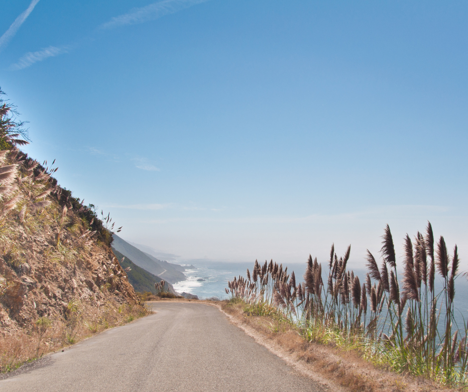
The Pacific Coast Highway stretches over 650 miles along California's stunning coastline, offering dramatic cliffs, pristine beaches, and charming coastal towns. Based on data from 100,000+ RVezy rentals, most travelers spend 5 to 10 days driving this route, with Class C motorhomes being the most popular choice because they balance comfort with easier handling on winding coastal roads. You'll travel primarily on Highway 1 and Highway 101, with Highway 1 offering the most dramatic ocean views between San Francisco and Los Angeles. The route passes through iconic destinations like Big Sur, Monterey, Santa Barbara, and Malibu, with endless pullouts for photos and exploration. RVezy renters typically book their California RV rentals 2-4 months ahead for peak summer season, though spring and fall offer better availability.
Choosing the Best California Coast Road Trip Route
Your route depends on where you start, how much time you have, and what kind of experience you want. Here's what works based on feedback from thousands of RVezy renters who've completed these coastal journeys.
The Classic San Francisco to Los Angeles Route (5-7 days)
This 450-mile journey represents the quintessential California coast road trip and covers the most famous sections of Highway 1. Start by picking up RV rentals in San Francisco, then head south through Half Moon Bay and Santa Cruz before reaching Monterey and Carmel.
The Big Sur coastline between Carmel and San Simeon showcases towering cliffs, crashing waves, and the iconic Bixby Bridge. Continue through San Luis Obispo and Santa Barbara before finishing in Los Angeles. This route takes 8-10 hours of pure driving time, but you'll want at least 5 days to actually enjoy the stops. Among RVezy's 100,000+ bookings, this represents the most popular California coastal route with peak demand from May through October.
The Extended Northern California Loop (7-10 days)
For travelers who want to include the redwood forests and rugged northern coast, this 800-mile route starts in San Francisco and continues north on Highway 101 through wine country before reaching the Avenue of the Giants and Redwood National Park. The northern coast offers fewer crowds and cooler temperatures year-round. After exploring the redwoods, loop back down Highway 1 through Mendocino and Bodega Bay before returning to San Francisco.
This route works beautifully from May through September when weather stays driest, and you can even extend inland to see Yosemite's famous Firefall event in February if timing your trip during winter months. RV rentals based in San Jose or Sacramento provide good starting points for this northern loop.
The Southern California Beach Route (4-6 days)
Perfect for travelers focused on beach towns and warmer weather, this 280-mile route runs from Los Angeles south to San Diego with stops in Malibu, Laguna Beach, and San Clemente. While less dramatic than Big Sur, this stretch offers excellent surfing beaches, tide pools, and charming coastal communities.
The route connects easily with inland destinations like Palm Springs if you want to add desert landscapes, and you can time your trip to catch events like Coachella or Stagecoach in April. RVezy data shows this southern route sees consistent bookings year-round since Southern California's mild climate makes it accessible even during winter months. Consider San Diego RV rentals for the best pricing if starting from the south.
The Complete California Coastal Journey (10-14 days)
The ultimate road trip combines everything from redwood forests to San Diego beaches, covering roughly 1,000 miles of coastline. Start in either San Francisco or San Diego and take your time exploring each region's unique character. This extended journey lets you experience the cool, foggy north, the dramatic central coast, and the sunny southern beaches without rushing.
Budget extra days for weather delays or road closures, which can affect Highway 1 especially during winter. Most RVezy renters completing this full route opt for Class A motorhomes for the added comfort during extended travel.
Should You Drive North or South on the California Coast Road Trip
Direction matters more than you might think when planning your Pacific Coast Highway journey. Here's what to consider:
Advantages of driving south (San Francisco → Los Angeles/San Diego):
- Better ocean views: You'll drive in the lane closest to the water, giving you unobstructed Pacific views throughout the journey. This positioning makes a significant difference on narrow coastal sections where the inland lane sits far from the edge.
- Easier photo stops: Pulling into scenic overlooks doesn't require crossing oncoming traffic, which improves safety and reduces stress when you spot a photo opportunity. You can enter and exit pullouts smoothly without waiting for traffic breaks.
- Superior afternoon light: Driving south means the sun stays behind you during afternoon hours, creating ideal photography conditions with fewer shadows and glare. The golden hour light hits coastal cliffs and beaches perfectly for stunning shots.
When driving north makes sense:
- Flight logistics: If you're flying into Los Angeles and out of San Francisco, driving north makes practical sense despite slightly reduced ocean visibility. The scenery looks equally stunning from either direction.
- Morning light preference: Photographers who prefer morning golden hour will appreciate northbound driving, with the sun illuminating coastal features during early drives. Morning tends to bring clearer skies before afternoon fog rolls in.
- Less crowded campgrounds: Some San Francisco Bay Area campgrounds and northern destinations see lighter traffic from southbound travelers, potentially offering better availability if you're heading north.
Based on RVezy platform patterns, roughly 65% of renters drive south while 35% go north, primarily determined by flight logistics rather than preference. Both directions deliver unforgettable experiences.
Breaking Down the Best Stops on a California Coast Road Trip
The Pacific Coast Highway offers hundreds of potential stops, but these consistently rank as favorites among RVezy renters and represent the highlights you shouldn't miss.
Big Sur: The Crown Jewel of Highway 1
This 90-mile stretch between Carmel and San Simeon delivers the most dramatic coastal scenery in California, with Highway 1 carved into cliffsides hundreds of feet above the Pacific.
Must-see Big Sur highlights:
- Bixby Bridge: The iconic concrete arch bridge provides the most photographed view along Highway 1. Arrive early morning or late afternoon to avoid crowds at the small pullout areas. The bridge spans a deep canyon with crashing waves below.
- McWay Falls at Julia Pfeiffer Burns State Park: An 80-foot waterfall drops directly onto a pristine beach in a scene that looks almost tropical. The short overlook trail makes this accessible to most visitors, though beach access is prohibited to protect the fragile ecosystem.
- Pfeiffer Beach: Features rare purple sand from manganese garnet deposits and dramatic rock formations including a natural keyhole arch. The access road challenges larger RVs with tight turns and low clearance, so check your vehicle's specifications before attempting.
- Point Sur Lighthouse: Offers guided tours if you want to stretch your legs and learn local maritime history. The lighthouse sits on a dramatic volcanic rock 361 feet above the ocean and requires a steep uphill walk.
Big Sur has limited services and no cell coverage in many areas, so fuel up in Carmel or Cambria and bring cash for park fees. Check Big Sur campground options well ahead since availability stays tight year-round. RVezy renters report that weekday visits to Big Sur feel significantly less crowded than weekends during summer.
Monterey and Carmel-by-the-Sea
Monterey combines natural beauty with excellent attractions while Carmel offers fairy-tale charm and artistic heritage.
What makes Monterey special:
- Monterey Bay Aquarium: Houses over 35,000 creatures and plants including mesmerizing jellyfish exhibits, playful sea otters, and the massive Open Sea tank with sharks and sea turtles. Book timed tickets online to avoid long entrance lines during peak season.
- Historic Cannery Row: Once the sardine canning capital immortalized by John Steinbeck, now offers restaurants, shops, and ocean views. The area gets crowded but provides excellent people-watching and fresh seafood dining options.
- Old Fisherman's Wharf: Features sea lions lounging on docks, whale watching tours, and clam chowder bread bowls. Street performers and local artisans add to the festive atmosphere, though prices skew touristy.
Carmel-by-the-Sea highlights:
- Fairy-tale cottages: The town features whimsical architecture with no street addresses, just house names and block numbers. Walking the residential streets feels like exploring a storybook village with immaculate gardens.
- Dog-friendly beach: Carmel Beach welcomes leashed dogs, making it popular with pet travelers. The white sand beach offers stunning sunsets and often features bonfires after dark when permitted.
- Art galleries: Over 100 galleries showcase everything from local landscape paintings to contemporary sculpture. First Fridays bring gallery walks with wine and artist meet-and-greets.
The 17-Mile Drive between Monterey and Carmel costs $11.25 per vehicle but showcases stunning coastal estates, golf courses, and the famous Lone Cypress tree. RV parking can be challenging in downtown Carmel, so use the public lots near the beach and walk into town. These adjacent communities work perfectly as a base for 2-3 days while exploring the surrounding area.
Santa Barbara: The American Riviera
This coastal gem sits about halfway between San Francisco and Los Angeles, making it an ideal overnight stop or longer destination. Spanish colonial architecture, palm-lined beaches, and a Mediterranean climate give Santa Barbara its nickname as the American Riviera.
Don't miss in Santa Barbara:
- State Street waterfront: The downtown corridor offers shopping, dining, and access to Stearns Wharf where you can watch dolphins and sea lions. Street performers and outdoor cafes create a lively European plaza atmosphere.
- Mission Santa Barbara: Called the "Queen of the Missions," this historic site dates back to 1786 and features beautiful Spanish colonial architecture, gardens, and a working fountain. Self-guided tours explain California's mission history and indigenous culture.
- Wine country access: The Santa Ynez Valley sits 45 minutes inland with over 100 wineries producing excellent Pinot Noir, Chardonnay, and Rhône varietals. The charming town of Solvang offers Danish architecture and bakeries perfect for afternoon stops.
- Beaches: East Beach provides the most amenities with volleyball courts, a snack bar, and gentle waves. Butterfly Beach in Montecito offers a more exclusive vibe where celebrity sightings happen regularly.
Among RVezy's 100,000+ rentals, Santa Barbara ranks as a top-requested destination with visitors typically spending 2-3 nights exploring the area.
Malibu and the Southern California Beaches
As you approach Los Angeles, Malibu delivers 21 miles of stunning Pacific coastline with famous surf breaks and celebrity homes tucked into hillsides.
Southern California beach highlights:
- Zuma Beach: Wide, sandy shores span 1.5 miles with lifeguards, restrooms, and excellent swimming conditions. This beach handles crowds better than smaller Malibu coves and offers ample parking though it fills quickly on summer weekends.
- Point Dume: Provides hiking trails leading to clifftop views where gray whales can be spotted during winter migration. The secluded cove beach below features tide pools and dramatic rock formations accessible via steep stairs.
- El Matador State Beach: Features dramatic sea stacks and sea caves accessible at low tide. This small beach requires descending steep stairs and offers no facilities, but the natural beauty justifies the effort for adventurous visitors.
- Neptune's Net: A weathered seafood shack frequented by motorcyclists serves fresh fish with ocean views. The casual atmosphere, generous portions, and oceanfront picnic tables make it a local favorite despite being right on Highway 1.
Further south, Laguna Beach showcases art galleries, tide pools, and numerous cove beaches including the picturesque Treasure Island Beach. RV parking becomes more challenging as you enter the LA metro area, so plan to use designated lots rather than street parking. Check Los Angeles area campground options to find suitable bases for exploring the region.
San Simeon and Hearst Castle
Perched on a hilltop overlooking the Pacific, Hearst Castle represents one of California's most extravagant attractions. Newspaper magnate William Randolph Hearst built this 165-room estate featuring European antiques, ornate pools, and expansive gardens on 250,000 acres.
What to know about Hearst Castle:
- Advance reservations required: Tours typically sell out weeks ahead during summer, so book as soon as you know your travel dates. Multiple tour options focus on different areas of the estate, with the Grand Rooms tour recommended for first-time visitors.
- Tour duration: Plan 2-3 hours including the bus ride up the hill and guided mansion tour. No food or drinks allowed inside, but the visitor center offers a cafe and gift shop.
- Evening tours: Seasonal twilight tours feature docents in 1930s period costume and the estate lit dramatically. These special tours cost more but provide a unique atmospheric experience.
The nearby town of San Simeon offers RV camping and beach access where elephant seals haul out on the sand year-round. Piedras Blancas Elephant Seal Rookery just north of San Simeon provides free viewing of these massive marine mammals, with peak numbers during breeding season from December through March.
Half Moon Bay and Pescadero
Just 30 minutes south of San Francisco, Half Moon Bay offers a quick escape with small-town charm and excellent coastal access.
What makes this area worth a stop:
- Pumpkin festival heritage: Each October, Half Moon Bay hosts California's largest pumpkin festival with over 250,000 visitors, giant pumpkin weigh-offs, and harvest celebrations. Book accommodations months ahead if visiting during festival weekend.
- State beach access: Multiple state beaches provide tide pooling, beach walks, and coastal trail hiking. Poplar Beach and Francis Beach offer the best facilities and easiest access from Highway 1.
- Pescadero charm: This tiny farming community 15 miles south deserves a stop for Duarte's Tavern, which has served legendary artichoke soup and olallieberry pie since 1894. The family-owned restaurant feels like stepping back in time with its vintage decor.
- Pescadero Marsh: Natural preserve attracts birdwatchers year-round with over 200 species spotted regularly including great blue herons, egrets, and occasional peregrine falcons. The easy walking trails loop through wetlands with interpretive signs.
Both towns provide a slower pace compared to San Francisco, with nearby RV rentals making the region accessible for weekend trips.
Planning Your California Coast Road Trip Timing
When you drive the Pacific Coast Highway dramatically affects your experience, from weather and crowds to road conditions and pricing.
Summer (June-August): Peak Season with Trade-offs
Summer brings the warmest ocean temperatures and longest days, but also the largest crowds and highest prices.
What to expect during summer:
- Coastal fog patterns: San Francisco and much of the northern California coast experience frequent fog during summer, with locals calling it "June Gloom" and "Fogust." The fog typically burns off by afternoon, but mornings can feel damp and gray with visibility limited.
- Big Sur sunshine: Points south of Monterey including Big Sur enjoy more reliable sunshine, making summer ideal for hiking and beach activities in these areas. Water temperatures peak at 60-65°F, still requiring wetsuits for comfortable swimming.
- Campground competition: Sites require reservations months in advance, and Highway 1 traffic moves slowly on weekends with popular viewpoints becoming parking challenges. State park campgrounds fill exactly six months out when reservations open.
- Premium pricing: Among RVezy bookings, summer RV rentals for California coast trips cost 25-40% more than shoulder seasons. Private campgrounds also charge peak rates with minimum stay requirements during holiday weekends.
However, summer offers the best conditions for swimming, kayaking, and ocean activities if you can handle the crowds and costs.
Spring (April-May) and Fall (September-October): The Sweet Spots
These shoulder seasons deliver the best combination of good weather, manageable crowds, and reasonable prices for a California coastal road trip.
Why experienced travelers choose shoulder seasons:
- Spring wildflowers: Coastal bluffs explode with California poppies, lupine, and wild mustard from March through May. Big Sur's hillsides transform into colorful carpets that photograph beautifully against blue ocean backgrounds.
- Whale migration: Gray whales head north from March through May, with multiple sightings possible from coastal viewpoints. Monterey offers excellent whale watching tours during spring migration with near-guaranteed sightings.
- Fall's peak conditions: September and October offer the warmest, clearest weather across the entire California coast, with summer fog patterns ending and winter rains not yet started. Water temperatures peak in September after months of summer sun warming.
- Better availability: You'll find campsite reservations possible just 2-4 weeks ahead instead of months. RVezy data shows strong booking activity during these months from experienced RV travelers who know to avoid peak summer crowds.
- Lower costs: Expect 20-35% savings on RV rentals and private campgrounds compared to summer rates. Many attractions also reduce admission prices outside peak season.
Spring and fall represent the ideal windows for first-time California coast road trippers seeking the full experience without summer's challenges.
Winter (November-March): Quiet Roads with Weather Risks
Winter transforms the California coast into a peaceful retreat with minimal crowds and the lowest rental rates, but comes with significant trade-offs.
Winter advantages and challenges:
- Storm watching: Massive Pacific swells crash against rocky shores, creating dramatic scenes at places like Point Lobos and Morro Bay. Winter storms bring 20-30 foot waves that photographers and surfers appreciate from safe distances.
- Whale migration south: Gray whales head to Baja breeding grounds from December through February, providing excellent viewing opportunities. Whale counts often exceed summer numbers with calmer ocean conditions making them easier to spot.
- Minimal crowds: You'll often have beaches, trails, and viewpoints entirely to yourself. State parks that require reservations six months ahead in summer may have same-day availability in January.
- Lowest pricing: RV rentals drop 30-50% below summer rates, and many private campgrounds offer weekly discounts to fill sites during slow periods.
Critical winter concerns:
- Highway closures: Heavy rains regularly wash out sections of Highway 1, especially along Big Sur where landslides can close the road for months. Always have inland alternate routes via Highway 101 planned as backup.
- Cold camping: Nights dip into the 40s even in Southern California, with northern sections seeing 30s regularly. RV heating systems work hard, and condensation becomes an issue without proper ventilation.
- Limited services: Some coastal attractions, restaurants, and campgrounds close or reduce hours during winter. Call ahead to confirm hours before planning stops around specific businesses.
Check road conditions daily via Caltrans if traveling during winter months. Southern California from Santa Barbara to San Diego stays relatively mild and makes the best winter destination along the coast.
Where to RV Camp Along the California Coast
The California coastline offers diverse camping options from full-hookup RV resorts to primitive state park campgrounds, each with distinct advantages.
State Park Campgrounds: Prime Locations
California State Parks operate numerous coastal campgrounds with oceanfront sites and basic amenities:
- Pfeiffer Big Sur State Park: Sits in a redwood canyon near the Big Sur coast, accommodating RVs up to 32 feet with no hookups. The canyon location provides protection from coastal winds while keeping you close to ocean attractions. Campsites offer picnic tables, fire rings, and access to the Big Sur River.
- Half Moon Bay State Beach: Offers RV camping with ocean views and easy access to trails and tidepools. Four separate campgrounds (Francis Beach, Venice Beach, Dunes Beach, and Roosevelt Beach) provide variety with similar amenities. Sites accommodate RVs up to 40 feet.
- Morro Bay State Park: Provides 140 campsites including RV sites with hookups (rare for California state parks), plus a natural history museum and golf course. The bay location offers calmer conditions than open ocean camping and excellent kayaking opportunities.
- San Clemente State Beach: Features blufftop camping overlooking the Pacific with sites for RVs up to 40 feet and full hookups at some locations. The campground sits right on the beach with trails down to sand and surf, plus lifeguards during summer.
These state parks typically cost $35-65 per night and require reservations through ReserveCalifornia up to six months in advance for summer dates. Based on RVezy renter experiences, booking exactly six months out when reservations open at 7am Pacific gives you the best selection.
Private RV Resorts: Full Amenities
Private campgrounds along the coast provide full hookups, WiFi, showers, and other conveniences that state parks lack:
- Monterey Peninsula options: Laguna Seca Recreation Area offers full hookups near the famous race track, while Marina Dunes RV Park provides direct beach access. Both deliver reliable WiFi and modern amenities important for working travelers or digital nomads.
- Santa Barbara Sunrise RV Park: Offers full hookups and easy access to downtown attractions via local bus routes. The park includes a pool, spa, and recreation room plus organized social activities during peak season.
- Malibu Beach RV Park: Sits directly on the beach, though it books up extremely far in advance and costs premium rates ($100+ per night). The oceanfront location and direct beach access justify the cost for special occasions.
These private facilities typically run $60-120 per night depending on location and amenities. Many RVezy renters mix state park camping with occasional stays at private resorts to dump tanks, do laundry, and recharge before continuing their journey.
Regional Campgrounds Worth Knowing
County-operated parks and private options sometimes fly under the radar compared to state parks but offer excellent value:
- Big Sur Campground and Cabins: Privately-owned riverside camping convenient to coastal attractions provides a reliable option when state parks fill. The property offers tent cabins, RV sites, and amenities including a store and laundry.
- Jalama Beach County Park: Remote beach camping near Santa Barbara offers a legendary burger stand and excellent surf fishing. The 28-mile drive on a narrow road from Highway 101 deters crowds, giving this spot a hidden gem quality.
- San Mateo County coastal parks: Several parks including Half Moon Bay's Pillar Point RV Park provide hookups and good access to beaches. County parks often have more availability than famous state parks while delivering similar coastal access.
These county and private facilities often have more availability than famous state parks while delivering similar coastal access. Check individual county websites since reservation systems vary by location. For comprehensive camping information, browse San Francisco Bay Area campgrounds to compare options.
Expanding Your California Adventure
If you have extra time or want to explore beyond the coast, several inland destinations connect easily with your coastal route:
- Lake Tahoe: Located 3-4 hours inland from San Francisco, Tahoe offers alpine beauty and year-round recreation. Check Lake Tahoe campground options if adding a mountain component to your coastal journey.
- Yosemite National Park: The iconic park sits about 4 hours from Monterey or San Francisco. Plan your visit around Yosemite's Firefall event in February if timing works, and browse Yosemite gateway campgrounds in Oakhurst for base options.
- Desert national parks: From Southern California, you can add Joshua Tree or Death Valley to your itinerary. See Joshua Tree campgrounds and Death Valley options for desert camping details.
Essential Tips for RVing the Pacific Coast Highway
Successfully navigating California's coastal highways in an RV requires awareness of specific challenges and smart planning strategies.
Managing Highway 1's Curves and Width Restrictions
Highway 1 through Big Sur features narrow lanes, tight curves, and no shoulders in many sections. Here's what you need to know:
- Size matters: RVs over 35 feet can struggle with sharp switchbacks, particularly around Hurricane Point and Devil's Slide. Some sections prohibit vehicles over 40 feet entirely, while others simply require extreme caution and slow speeds.
- Towing complications: Adding a car behind your RV significantly increases length and complexity for tight maneuvers. Consider whether towing is worth the hassle on Highway 1's most challenging sections, or plan to use Highway 101 inland as an alternative.
- Optimal RV size: Based on RVezy owner recommendations, motorhomes in the 25-30 foot range handle the Pacific Coast Highway most confidently. You'll navigate curves with less stress and fit into campground sites more easily.
- Alternative routes: If you're renting something larger than 30 feet, consider taking Highway 101 inland as an alternative route through more RV-friendly terrain, rejoining Highway 1 at easier sections. The southern stretch from Santa Barbara to Los Angeles presents fewer challenges with wider roads.
Monitoring Road Closures and Conditions
Highway 1 frequently closes due to landslides, particularly through Big Sur where the highway clings to unstable cliffs. A single winter storm can shut down sections for months or even years while repairs are made.
Stay informed with these strategies:
- Daily condition checks: Before your trip and each morning during travel, check Caltrans QuickMap for current conditions and closures. The website and mobile app show real-time road status throughout California.
- Multiple information sources: Use the Caltrans 511 phone system, local news, and RV forums for closure updates. Big Sur chambers of commerce often post detailed detour information on social media.
- Buffer days: Some RVezy renters build extra buffer days into their itinerary specifically to accommodate unexpected detours. This flexibility reduces stress when closures force route changes.
- Backup routes ready: Have inland routes via Highway 101 mapped and programmed into your GPS before departures. Knowing your detour options in advance prevents fumbling with maps when you encounter closure signs.
Fuel and Propane Considerations
Gas stations along Highway 1 appear infrequently, especially through Big Sur where a 90-mile stretch has virtually no services.
Fuel planning essentials:
- Fill early, fill often: Top off your RV tank whenever you see a station rather than waiting until you're running low. Coastal fuel prices run 20-40% higher than inland areas due to limited competition and transportation costs.
- Big Sur fuel desert: The stretch from Carmel to Cambria offers minimal services. Fuel up before entering Big Sur and don't expect reasonable prices at the few stations that do exist.
- Propane challenges: Refills present even more difficulties than gasoline, with many coastal towns lacking RV-friendly propane stations. Plan to refill in larger cities like San Francisco, Monterey, Santa Barbara, or Los Angeles rather than assuming small coastal towns will have propane.
- Generator considerations: Carry extra fuel stabilizer if your RV has a generator since you may go extended periods between fill-ups. Some campgrounds restrict generator hours or prohibit them entirely, so verify policies before planning to run your generator.
Parking and Maneuvering in Coastal Towns
Charming coastal villages feature narrow streets and limited parking designed for a pre-RV era. Smart navigation prevents stress and potential damage.
Parking strategies that work:
- Scout locations ahead: Use Google Maps satellite view before arriving to identify RV-friendly lots. Street View helps confirm turning radius requirements and parking lot entrance widths.
- Park and walk: Find RV parking on the outskirts of towns like Carmel, Mendocino, and Cayucos, then explore on foot or bike. Downtown areas rarely accommodate large vehicles comfortably.
- Designated RV areas: Many attractions like Hearst Castle have separate RV parking areas with easier access than regular lots. State beaches often accommodate RVs in beachfront lots, though arriving early on summer weekends matters.
- RV-friendly towns: Morro Bay, Pismo Beach, and Ventura designed their waterfronts with RV access in mind. These towns provide easier parking and wider streets for larger vehicles.
Packing for Your California Coastal RV Adventure
California's coast presents unique packing challenges due to variable weather, limited services in some areas, and specific activity opportunities.
Layered Clothing for Microclimates
California's coastal microclimates mean you might experience 50°F fog in the morning and 75°F sunshine by afternoon, sometimes with 20-degree temperature differences between coastal towns just 20 miles apart.
Essential clothing items:
- Base layers: Moisture-wicking long underwear and t-shirts provide foundation for layering system. Merino wool or synthetic fabrics dry quickly and resist odors better than cotton.
- Insulating mid-layers: Fleece jackets or down vests add warmth without bulk. Even summer trips require these for foggy mornings and cool evenings, especially in Northern California.
- Waterproof outer shells: A good rain jacket protects from drizzle, wind, and ocean spray. Packable options save space when weather clears and temperatures rise.
- Footwear variety: Sturdy hiking boots with ankle support matter for coastal trails and tide pools where rocks get slippery. Comfortable walking shoes handle town exploration, while sandals work around camp.
- Sun protection essentials: Wide-brimmed hats, quality sunglasses, and reef-safe sunscreen provide defense against intense UV exposure amplified by coastal reflection.
Beach and Ocean Gear
California's Pacific waters stay surprisingly cold year-round, with proper equipment making the difference between enjoyment and teeth-chattering misery:
- Wetsuits for swimming: Water temperatures range from 52°F in winter to 65°F in late summer, making wetsuits essential for comfortable ocean swimming. Many visitors overestimate water temperature based on air temperature and find the Pacific shockingly cold.
- Beach comfort items: Chairs, towels, and sand toys if traveling with kids enhance beach days. Wind protection like popup canopies helps on breezy afternoons.
- Water sports equipment: Boogie boards or surfboards add fun to beach days, with many coastal towns offering rentals if you don't want to pack your own. Stand-up paddleboards work well in calmer bays and harbors.
- Tide pool exploration: Sturdy water shoes with good grip prevent slipping on algae-covered rocks. Polarized sunglasses help spot marine life in pools, while a small bucket lets kids temporarily observe creatures before returning them.
- Whale watching aids: Binoculars enhance your ability to spot gray whales during migration seasons from December through May. They also work for viewing sea otters, seals, and coastal birds.
Photography and Navigation Equipment
The Pacific Coast Highway delivers world-class photography opportunities and requires reliable navigation through areas without cell service:
- Camera equipment: Bring proper gear or ensure your phone has adequate storage space and battery life. Portable phone chargers keep devices ready for navigation and photos throughout long driving days.
- Physical maps: Cell service disappears through remote sections like Big Sur, making paper maps essential backup. A California road atlas helps with detour planning if Highway 1 closures force alternate routes.
- Dash cameras: Mount easily for hands-free video of scenic drives through Big Sur's spectacular sections. GoPro or action cameras work well for capturing driving footage and hiking adventures.
- Binoculars: Spot marine life, distant coastal features, and details on offshore rocks or islands. Essential for whale watching and bird identification.
Food and Cooking Supplies
Big Sur has essentially no grocery stores for 90 miles, while other coastal towns feature small markets with tourist prices. Smart provisioning saves money and ensures meal options.
Kitchen essentials for coastal RVing:
- Non-perishable staples: Stock up before starting your trip with pasta, rice, canned goods, and snacks. Plan for 3-4 days between major grocery shopping opportunities in larger cities.
- Spice and condiment kit: Elevates RV cooking significantly beyond basic meals. Include cooking oil, salt, pepper, garlic, and your favorite seasonings in a compact organizer.
- Fresh additions: Local markets and roadside stands offer seasonal produce and fresh seafood that add variety to meals. Farmers markets in towns like Monterey and Santa Barbara provide excellent ingredients.
- Beach fire supplies: Many coastal campgrounds allow beach fires, so bring s'mores ingredients, hot dog roasting sticks, and firewood if permitted. Check fire restrictions which often prohibit beach fires during dry season.
- Coffee system: Whether that's a camp percolator, French press, or portable espresso maker, most travelers consider morning coffee essential. Bring your preferred brewing method and enough coffee for the entire trip.
Frequently Asked Questions About California Coast Road Trips
How many days do you need for a California coast road trip?
Plan at least 5-7 days to drive from San Francisco to Los Angeles while actually enjoying the highlights rather than just covering miles. Among RVezy's 100,000+ bookings, the average California coast trip spans 7-9 days. A full week lets you spend 2-3 days in Big Sur area, explore Monterey and Carmel, and stop at Santa Barbara without constant driving. Two weeks works better if you want to include the northern redwood coast or extend south to San Diego. Weekend warriors can tackle shortened segments like San Francisco to Monterey in 2-3 days.
What is the best route for a California coast road trip?
The classic San Francisco to Los Angeles route via Highway 1 showcases California's most dramatic coastal scenery and represents the quintessential Pacific Coast Highway experience. This 450-mile journey takes you through Big Sur, Carmel, and Santa Barbara while keeping the ocean on your right if driving south. Alternatively, starting in Los Angeles and driving north works equally well, with RV rentals available throughout Southern California providing flexible pick-up options. If you're in LA for events like the Rose Bowl, you can easily start your coastal journey from there.
Can you do a California coast road trip in an RV?
Absolutely, and many travelers consider RVs the ideal way to experience the California coast since you control your schedule and accommodations while accessing campgrounds in prime coastal locations. Class C motorhomes in the 25-30 foot range work best for Highway 1's curves and campground size restrictions. Larger Class A coaches handle better on Highway 101 inland routes. RVezy data shows consistent strong demand for California coastal RV trips, with renters appreciating the flexibility to stop at scenic pullouts and camp near the ocean rather than backtracking to distant hotels.
Where can you RV camp along the California coast?
California State Parks operate excellent coastal campgrounds including Pfeiffer Big Sur, Half Moon Bay State Beach, and San Clemente State Beach, most accommodating RVs up to 32-40 feet depending on the specific park. Private RV resorts in Monterey, Santa Barbara, and near Los Angeles provide full hookups and amenities. County parks like Jalama Beach offer additional options. Book state park sites exactly six months in advance when reservations open for best selection during peak season. RVezy renters consistently recommend mixing different campground types to balance cost, amenities, and location.
Is the Pacific Coast Highway open year-round?
Most of Highway 1 stays open year-round, but the Big Sur section frequently closes due to landslides and storm damage, sometimes for months at a time. Winter storms between November and March create the highest closure risk. Always check current conditions via Caltrans before your trip and build flexibility into your itinerary for potential detours via Highway 101 inland. The southern sections from Santa Barbara to Los Angeles and San Diego rarely close, while the far northern coast may see temporary closures during severe winter weather.
What part of the California coast is the most scenic?
Big Sur between Carmel and San Simeon consistently ranks as the most dramatic and photographed section of California coastline, with Highway 1 carved into cliffsides hundreds of feet above the Pacific Ocean. The 90-mile stretch includes Bixby Bridge, McWay Falls, and countless viewpoints overlooking rugged shores. However, the entire coast offers distinct beauty from the redwood forests near Mendocino to the Mediterranean-style coastline around Santa Barbara. RVezy renters often cite Big Sur as their highlight while appreciating the variety along the entire route.
Is Highway 1 better than Highway 101 for a road trip?
Highway 1 delivers far superior ocean views and coastal access compared to Highway 101, which runs inland through much of California. Take Highway 1 whenever possible for the quintessential Pacific Coast Highway experience. However, Highway 101 provides practical advantages including faster speeds, easier driving for large RVs, and reliability since it rarely closes. Smart travelers use Highway 1 for scenic sections like Big Sur while switching to Highway 101 for faster transit or when Highway 1 closures force detours. Both highways have their place in a well-planned California coast road trip.
What are the best stops on a California coast road trip?
Don't miss Big Sur for dramatic clifftop ocean views, Monterey for the world-class aquarium and Cannery Row, Carmel for charming village atmosphere, Santa Barbara for Spanish colonial architecture and beaches, and Malibu for surf culture and celebrity watching. Secondary gems include Half Moon Bay, San Simeon for Hearst Castle, San Luis Obispo, and Laguna Beach. Allow flexibility to discover your own favorites at lesser-known state beaches and viewpoints. The journey matters as much as specific destinations on a California coastal road trip.
Should you drive north or south on a California coast road trip?
Driving south from San Francisco to Los Angeles keeps you in the lane closest to the ocean, providing better views and easier access to pullouts without crossing traffic. Photography also works better with afternoon sun at your back. However, practical factors like flight schedules often determine direction, and the scenery looks equally spectacular either way. Among RVezy renters, about two-thirds drive south while one-third go north based primarily on logistics rather than strong preference.